
Sultan Fatih’s Conquest of Constantinople, The Event That Changed History
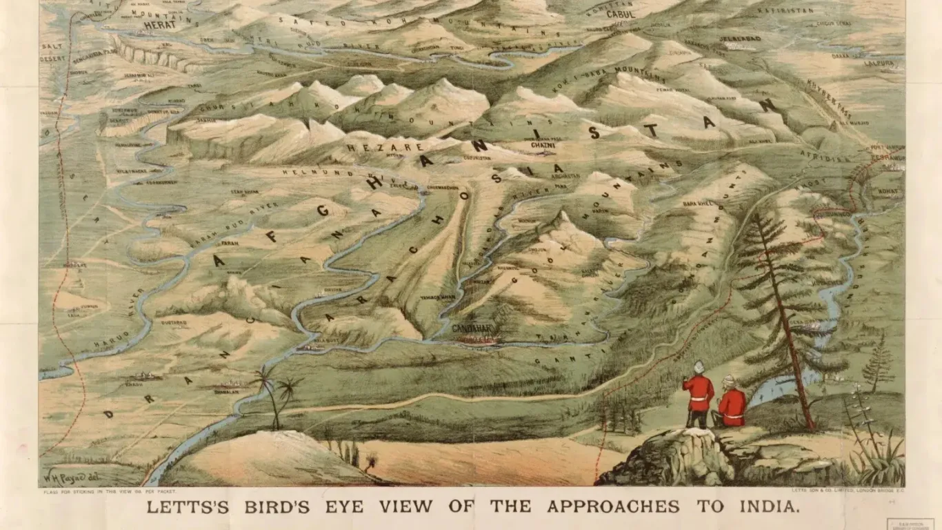
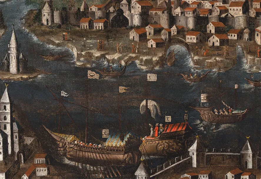
(A 16th century oil painting commissioned to commemorate a celebrated ancestor, Luchino Dal Verme (c1320–67), https://www.cornucopia.net/blog/constantinopoli-circa-1600) “If the entire world were a single state, Istanbul would be its capital.” The quote is famously attributed to Napoleon Bonaparte, a reflection of the city’s unmatched strategic and civilizational significance. On 29 May 1453, a city long regarded as unconquerable finally fell. Constantinople, known throughout history as Byzantium, the Queen of Cities, Istinpolin, Stamboul, and eventually Istanbul, was conquered by the armies of the Ottoman Sultan Mehmed II. At only twenty-one years of age, the seventh Ottoman ruler accomplished what generations of emperors, caliphs, and commanders had sought before him. History would remember him as Mehmed the Conqueror, the Fatih of Kustuntuniyya. Yet the story of the conquest begins long before the Ottomans appeared outside its walls. From Byzantium to Constantinople The city traces its origins to 657 BC, when a Greek ruler named Byzas founded a settlement on the European side of the Bosporus Strait. Known as Byzantium, the settlement flourished because of its location. Positioned at the crossroads of Europe and Asia, it controlled access between the Black Sea and the Mediterranean. In AD 330, Roman Emperor Constantine transformed the city into his “New Rome,” establishing it as the capital of the Eastern Roman Empire. As Christianity became the empire’s defining faith, Constantinople emerged as one of the most influential cities in the world. Its wealth, learning, trade, and political importance earned it the title of the “Queen of Cities.” Researchers have noted that ancient Byzantium had never become a truly major city before Constantine. Its natural role was to serve as a gateway to the Black Sea. Constantine’s decision elevated it into something far greater, a capital that would shape the destiny of empires for over a millennium. Its geographical position remains just as important today. Istanbul, today physically straddles the Bosporus, the narrow waterway connecting the Black Sea to the Sea of Marmara and ultimately the Mediterranean. For Black Sea nations, it remains the only maritime gateway to the world’s oceans. The Walls of an Empire Despite its strategic advantages, Byzantium possessed a serious weakness. Unlike many ancient capitals, it lacked strong natural barriers against attacks from the hinterland. To compensate, massive defensive walls were constructed. Completed under Emperor Theodosius II in AD 413, the famous Theodosian Walls transformed Constantinople into one of the most heavily fortified cities in history. Consisting of multiple defensive layers, towers, and moats, they protected the city for centuries. (The walls have been designated as a UNESCO world heritage site since 1985.) The walls soon became legendary. As the capital of the Byzantine Empire, Constantinople survived siege after siege. Arab armies in the seventh and eighth centuries failed to breach its defenses. Bulgarians and Rus armies met similar fates in later centuries. The city became synonymous with endurance. But during the Fourth Crusade in 1204, crusaders diverted from their original mission and brutally sacked the city, establishing a Latin state. Although Byzantine rulers recaptured Constantinople in 1261, the empire never fully recovered. By the fifteenth century, the city remained the principal population center of an empire that had largely faded into a shadow of its former self. Islam, Anatolia, and the Road to Constantinople Muslim contact with Anatolia began in the seventh and eighth centuries when Arab armies from the Umayyad and Abbasid Caliphates reached Byzantine frontier regions. Through trade, military encounters, and cultural exchanges, Islam gradually spread among the Turkic peoples of Central Asia. A decisive turning point came in 1071 at the Battle of Manzikert. There, the Seljuk Sultan Alp Arslan defeated the Byzantine army in one of the most consequential battles of medieval history. The victory opened much of Anatolia to Turkic settlement and accelerated the region’s transformation. Yet Constantinople itself remained beyond reach. For centuries, Muslim rulers and armies sought its conquest. The city continued to stand behind its walls, seemingly invincible. By the middle of the fifteenth century, however, a young Ottoman ruler was determined to change that reality. The Sultan and the Prophecy (Portrait of Mehmet II by Gentile Bellini, dating 1480) When Mehmed II ascended the Ottoman throne for the second time, he directed his attention toward Constantinople. Unlike many of his predecessors, he was unwilling to preserve the status quo. For Mehmed, Constantinople represented more than a strategic objective. It was a powerful Christian enclave surrounded by expanding Muslim territories, a political and military center that had repeatedly supported coalitions against Muslim powers. The memory of Byzantine involvement with crusading efforts, including campaigns such as Nicopolis, remained fresh. When Byzantines abetted Crusader against his grandfather. The city also carried immense symbolic significance. A famous narration attributed to Prophet Muhammad (SAW) states: “You will conquer Constantinople. The best commander is its commander and the best army is its army.” (Scholars have differed regarding the authenticity of the specific wording praising the commander and army. However, the prophecy concerning the conquest of Constantinople itself appears in authentic Islamic sources, including Sahih Muslim.) For generations, Muslim rulers viewed the city’s conquest as a noble aspiration. Mehmed intended to be the one who fulfilled it. Preparing for the Impossible At twenty-one years old, Mehmed launched one of the most ambitious military projects of the medieval era. To isolate Constantinople, he ordered the construction of Rumelian Castle on the European shore of the Bosporus. Completed in only four months, the fortress enabled Ottoman artillery to dominate maritime traffic entering the city. Mehmed personally involved himself in planning every aspect of the campaign. He studied maps, examined the walls, designed siege works, and encouraged innovations in military technology. It is written that Mehmed spent his nights sketching the city walls by candlelight, mapping out trenches, and designing movable wooden siege towers. His crown jewel was a revolutionary, 600 kg super-cannon utilizing a brand-new combined firing technique, a massive bombard capable of firing enormous stone projectiles against fortifications previously considered indestructible. In March 1453, he marched toward Constantinople with an army estimated at
Sultan Fatih’s Conquest of Constantinople, The Event That Changed History Read More »